
Geography of Aurora
by Jesus T. Peralta
'Aurora' refers to either the northern lights (aurora borealis) or the southern lights (aurora australis), a natural phenomenon characterized by the appearance of streamers of colored light in the sky near the earth's magnetic poles and caused by the interaction of charged particles from the sun with atoms in the upper atmosphere. By poetic extension, the word also means dawn, goddess of the dawn.
A Landscape of Contrasts
The province of Aurora, named after the wife of former president of the Philippines, Manuel L. Quezon, is aptly enough also where the rays of the sun first dawns in this country.Contrast to this the severity of the landscape. The Sierra Madre Mountain Range, which extends south from the extreme northeastern side of the country into of the Eastern Cordillera, comprises the common physiographic structure upon which the entire region is defined. This lofty highland system is continuous and lies parallel to the eastern coastline of Luzon. The rocky eastern slopes form an almost inaccessible shoreline that is exposed to the full force of the northeast trade winds and the continual buffeting of the waves and surf of the Pacific Ocean. This rather sterile rampart of eastern Luzon extends from Cape Engano in the northeastern corner of the island southward to Dingalan Bay for a length of some 576 kilometers through the isthmus of Quezon into the Bondoc Peninsula. The coastline is rocky and steep, highly forested, and with cliffs rising abruptly into the massive mountain system. Few bays break into the northern part of the coast. The only relatively lowland areas are found in the vicinities of Palanan, Casiguran, and Baler bays.
Eastern Luzon, for a long time has not offered a very hospitable environment for habitation because it is heavily forested and provided with excessive precipitation, making for its relative inaccessibility. It was only because of the extensive population pressures on the central plains of Luzon that settlers were forced into this littoral area. Even today, agriculture is of very minor significance except for some rather large areas in the south that is planted with coconuts. Most of the regional economy is tied to forest exploitation.
The province is located at the east-central side of the island of Luzon. The region is a combination of a small number of coastal lowlands and very rugged and mainly inaccessible highland interior composed of the Eastern Cordilleras of Luzon and the northern extension of the Sierra Madre Range. The descent of the land is very abrupt, leaving very little development on the coastal plains. There are many short but swiftly flowing streams that did not develop deltas out into the deep waters lying very close inshore. The coast lacks good harbors. The entire coastline is exposed to the full effects of the moist air masses and the raging typhoons of the western Pacific Ocean. Throughout the entire coastline, rainfall is constant and abundant.
The Province of Aurora
Aurora is the northernmost province of the Southern Tagalog political division (Region IV). In the north, the provinces of Isabela and Quirino hem it in. Directly west of it are the provinces of Nueva Ecija and Nueva Vizcaya, while the Bulacan and Quezon provinces are located south. The entire 328 kilometers eastern side of Aurora fronts the western side of the Pacific Ocean. The province forms part of the eastern side of the Sierra Madre Mountains and is characterized by high and rugged mountainous terrain. The chain is broken only at certain points through the mountains by which the province is accessed by the rest of Luzon, otherwise Aurora can only be approached by water from the Pacific Ocean. Many short, fast-moving mountain streams throughout the long coast and six rivers drain Aurora.
Most of eastern Luzon lies fully open to the northeastern airflows from the Pacific Ocean. Exposed locations receive annual precipitation that is in excess of 2,540 millimeters. Generally the period from October to March experience the heaviest rainfall however the other months are not necessarily dry.
Typhoons pose a constant danger. Although they can come at any time, they are most prevalent in the period from September to December. Typhoons that approach from the east or southeast of the island of Leyte and Samar and cross over the archipelago north of Manila are particularly dangerous, because their paths traverse directly through eastern Luzon. Those that pass south of Manila are no less dangerous since they bring very strong northeast to southeast winds and heavy rain.
Rainfall in the province is rather evenly distributed throughout the year, and the monthly average is 273.9 millimeters. The precipitation is heaviest during the months of January, February, April, October, and November. August is the month with the driest record. The mean monthly temperature is 25.3 degrees Celsius. The coldest months come on during the onset of the northeast wind currents blowing from mainland Asia during January and February, with the temperature ranging from 19.3 to 20.4 degrees Celsius. The total land area of the province is 309,707 hectares comprising of approximately 1% of the total land area of the Philippines. Some 230,000 hectares of this is given to forests that compose about 70% of the land area. The virgin dipterocarp forest comprises some 39,000 hectares. More than half of the province has either steep or very steep slopes and only 14 % of the area is flatland.
Natural Resources
The province is rich in mineral resources; copper, iron, chromites, manganese, gold, and nickel are abundant. There are also rich deposits of non- metallic minerals like guano, black sand, cement, marble, carbon, and silica. The province is also rich in other resources like sabutan, coconut, nipa, bamboo, gravel, sand, wood, rattan, shell, buri, and nito. The resources are largely untapped due to lack of investment.
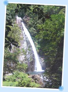
Aurora has many natural tourist attractions. Its waterfalls, beaches, lush green mountains, deep-blue ocean are stunning. So are the country pastures and farmlands. Much of the resources remains undeveloped and can be considered important for growth.
Getting to Aurora
There is a road link in Cabanatuan to Dingalan that can be accessed through the Canili-Pantabangan route, leading into the town of Maria Aurora. Some portions of the route are very steep. Roads connect Baler to Manila. The Baler-Bongabon road leads to the town of San Luis and finally ends in Baler. This is the more commonly used route. There is continual upgrading of this road that includes cementing. To get around Aurora by sea there are a number of recourses. Passenger boats are available from Duungan, located in riverbank leading to Baler Bay and the Poblacion. Docked along the bank are boats for trips to Dinalungan, Casiguran, and Dilasag.
A total road network of 1,507,682 kilometers link key areas in the province of which 97% (or 1,468,061 kilometers) is surfaced by gravel, less than 1 % (or 7,736 kilometers) asphalt-covered, and the remaining 2% (or 31,885 kilometers) concrete. During the height of the rainy and monsoon season the gravel roads are difficult to access since much of these can be found in mountainous terrain that are prone to landslides and road cuts. Most of the roads lack adequate drainage resulting in erosion and accumulation of water in the roadways. The coastal road along Baler and Casiguran are made of fine sand and is difficult to traverse for small vehicles especially when the sand grains are dry.
Aurora has six ports in all. Four are municipal ports located in Baler and Casiguran. Two ports are privately owned and often used during the height of the rainy season when the Baler-Casiguran road is not safe to use. These two are used to travel between Baler and Dilasag. There is an airport in San Luis maintained by the Philippine Army that can accommodate Cessnas, Fokkers, and Islanders, and other light planes and helicopters. Flight takes about 45 minutes and the airfield is 25 minutes away from Baler. Another private airstrip is in Motyong, Casiguran, owned by logging concessionaires.
Households obtain water supply principally using water pumps, which account for 91% of the total water facilities. Of the municipalities, Casiguran and Dipaculao have the most difficulty in sourcing water. Baler has the least problem with respect to water access.
All the municipalities of Aurora are served by electricity with Baler having the most households served. The Luzon grid of the National Power Corporation, through the Aurora Electric Cooperative, Inc., generates the power; or the 5 MVA power substation of AURELCO located in Barangay San Isidro, San Luis, which uses a 69 KV power transmission source that reaches the barangays of Baler and San Luis.
Communication with the province is made possible by some thirty facilities. Telecommunication facilities are made up of five public and two private telegraph stations, and four privately owned systems of radio communication. This includes RCPI and PT&T for telegraph service, long distance and overseas calls. There is an office of the Bureau of Telecommunication (BUTELCO) in Casiguran, with AZ Communication in Baler as the transmitting station. Access to high-speed Internet services is also available in Baler. The Aurora State Colleges provides these services to students, faculty, and staff. To handle communication between municipalities a Provincial Law Enforcer Communication System (PLECS) has been established, which is particularly useful during times of emergency. Widely distributed throughout the province also are hand-held radios, transceivers, and single sideband radios usually through the communication networks of regional or central offices. There are post offices in each of the municipalities, with Baler having two. Postal service is under the Bureau of Posts.
The provincial population is 173,797 (NSO 2000). There are 35,873 households with an average size of 5.1 members. The population density is 54 per square kilometer. The predominantly rural population is approximately 131,829 with an annual growth of 1.84%, making Aurora the least populated province of Region Iv: Only 24.2 % live in urban areas. There are 108 males for every 100 females. 40.90% of the population are below 15 years. The largest age group is between 15 and 65 and this make up 55.60% of the total population. Those ages 65 and above comprise 3.50%. The literacy rate is 94.54%.
The major crops are coconut (23,285 hectares of land) and rice (21,720 hectares). Fishing is also a major industry.